
| Woodrow Wilson Bridge Project Photos - January 2007 |
The following 28 photos show various aerial views of the I-95/I-495 Woodrow Wilson Bridge (WWB) Project construction, including the new Potomac River Bridge construction, the Virginia U.S. Route 1 Interchange construction, and the Washington Street Urban Deck construction, and the Maryland Interstate 295 Interchange construction.
These photos were taken on January 31, 2007 by the Virginia Department of Transportation, and are posted here with their permission. Roads to the Future utilized PhotoDeluxe Business Edition to sharpen and brighten and to align all of the photos. Click on the photo to get a large version of the photo. In later versions of Netscape and Internet Explorer, you probably will need to use Full Screen mode (the F11 key can be utilized to swap back and forth between Full Screen and Regular) to see the full size of the large photo without browser-induced image shrinkage. The large photos have sizes ranging from 70 to 270 kilobytes, with most of them being under 221 kilobytes. The photos marked "LARGE PHOTO" are much larger, with a very detailed zoom-in of the previous photo, and they have the file size listed next to the photo. With a broadband or network Internet connection each photo will download within seconds, but with a dial-up Internet connection it will be somewhat slower.
 |
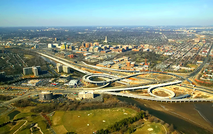
U.S.
Route 1 Interchange construction, looking north across Hunting Creek and
the I-95/I-495 Capital Beltway, with Alexandria, Virginia, on the north
side of the Beltway. The Potomac River is in the upper part of the photo,
and the Woodrow Wilson Bridge is in the upper right of the photo. Maryland
and Washington, D.C. is on the opposite side of the Potomac River. These aerial views of the U.S. Route 1 Interchange construction, are in order as taken from a helicopter as it flew a loop around the interchange area. |
 |
U.S. Route 1 Interchange construction, looking north across Hunting Creek and the I-95/I-495 Capital Beltway, with Alexandria on the north side of the Beltway. |
 |
U.S.
Route 1 Interchange construction, looking north across Hunting Creek and
the I-95/I-495 Capital Beltway, with Old Town Alexandria on the north side
of the Beltway. The Beltway runs left to right, and US-1 runs from lower
left to the upper middle.
Notice the new 3-lane northbound US-1 bridge under construction, which passes over Hunting Creek, low-lying land, and the Beltway. Notice the loop ramp under construction from the Beltway Outer Loop (to WWB) to northbound US-1. The new US-1 bridge and ramp is expected to open to traffic on the weekend of March 3-4, 2007. Then the pre-existing US-1 bridge will be demolished so that the new 3-lane southbound US-1 bridge can be constructed. |
 |
U.S. Route 1 Interchange construction, looking northwest across Hunting Creek and the I-95/I-495 Capital Beltway, with Alexandria on the north side of the Beltway. |
 |
U.S. Route 1 Interchange construction, looking northwest across Hunting Creek and the I-95/I-495 Capital Beltway, with Alexandria on the north side of the Beltway. |
 |
U.S. Route 1 Interchange construction, looking west across Hunting Creek and the I-95/I-495 Capital Beltway, with Alexandria on the north side of the Beltway. The Beltway runs from bottom to top, and US-1 runs from left to right. |
 |
U.S. Route 1 Interchange construction, looking west across Hunting Creek, and the I-95/I-495 Capital Beltway, with Alexandria on the north side of the Beltway. The Washington Street Urban Deck is under construction in the lower right of the photo. |
 |
Looking west along the Beltway, showing construction of the Washington Street Urban Deck in Alexandria VA, and the U.S. Route 1 Interchange in the distance. The Washington Street Urban Deck has been completed over the future local and express Beltway Outer Loop roadways, with Beltway traffic operating there; and it is under construction over the future local and express Beltway Inner Loop roadways. |
 |
U.S. Route 1 Interchange construction, looking south along U.S. Route 1 which goes into the distance in the upper left, with the Beltway running lower left to upper right. |
 |
U.S.
Route 1 Interchange construction, looking south along U.S. Route 1 which
goes into the distance, with the Beltway running left-right. Notice the flyover ramp under construction and partially built, that will handle the movement from northbound US-1 (from Fairfax County) to the Beltway Inner Loop (toward Springfield). Notice the new 3-lane northbound US-1 bridge under construction, which passes over Hunting Creek, low-lying land, and the Beltway. Notice the loop ramp under construction from the Beltway Outer Loop (to WWB) to northbound US-1. The new US-1 bridge and ramp is expected to open to traffic on the weekend of March 3-4, 2007. Then the pre-existing US-1 bridge will be demolished so that the new 3-lane southbound US-1 bridge can be constructed. |
 |
U.S. Route 1 Interchange construction, looking south along U.S. Route 1 which goes into the distance, with the Beltway running left-right. The Potomac River is visible in the upper left of the photo. |
 |
U.S. Route 1 Interchange construction, looking south across the Beltway and Hunting Creek, with the Beltway running upper left to lower right. The Potomac River is visible in the upper left of the photo. |
 |
U.S. Route 1 Interchange construction, looking south across the Beltway and Hunting Creek, with the Beltway running upper left to lower right. The Potomac River is visible in the upper left of the photo. |
 |
U.S. Route 1 Interchange construction, looking east along the I-95/I-495 Capital Beltway, with Alexandria on the north side of the Beltway, and the Potomac River, the Woodrow Wilson Bridge, and Maryland, visible in the distance. |
 |
U.S. Route 1 Interchange construction, looking east along the I-95/I-495 Capital Beltway, with Alexandria on the north side of the Beltway, and the Potomac River, the Woodrow Wilson Bridge, and Maryland, visible in the distance. |
 |
U.S. Route 1 Interchange construction, looking northwest across Hunting Creek and the I-95/I-495 Capital Beltway, with Alexandria on the north side of the Beltway. The Beltway heads west into the distance in the upper left of the photo. |
 |
U.S. Route 1 Interchange construction, looking north across Hunting Creek, and the I-95/I-495 Capital Beltway, with Alexandria on the north side of the Beltway. The Washington Street Urban Deck is under construction in the lower right of the photo. |
 |
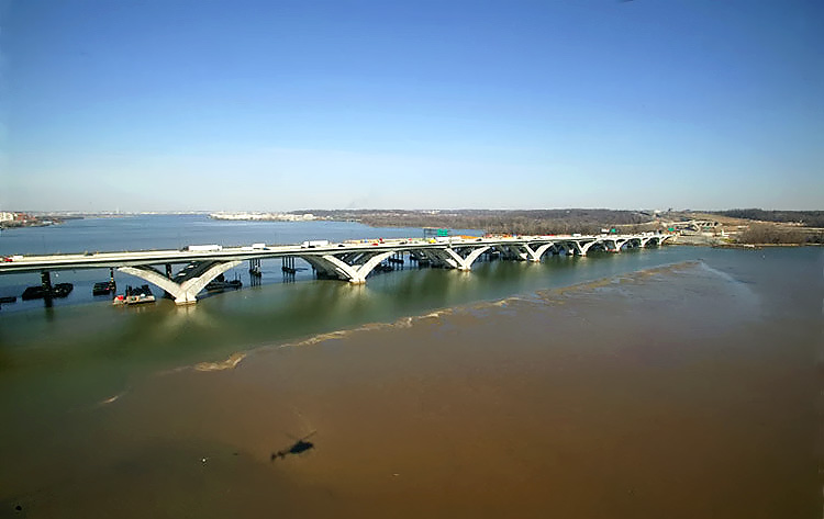
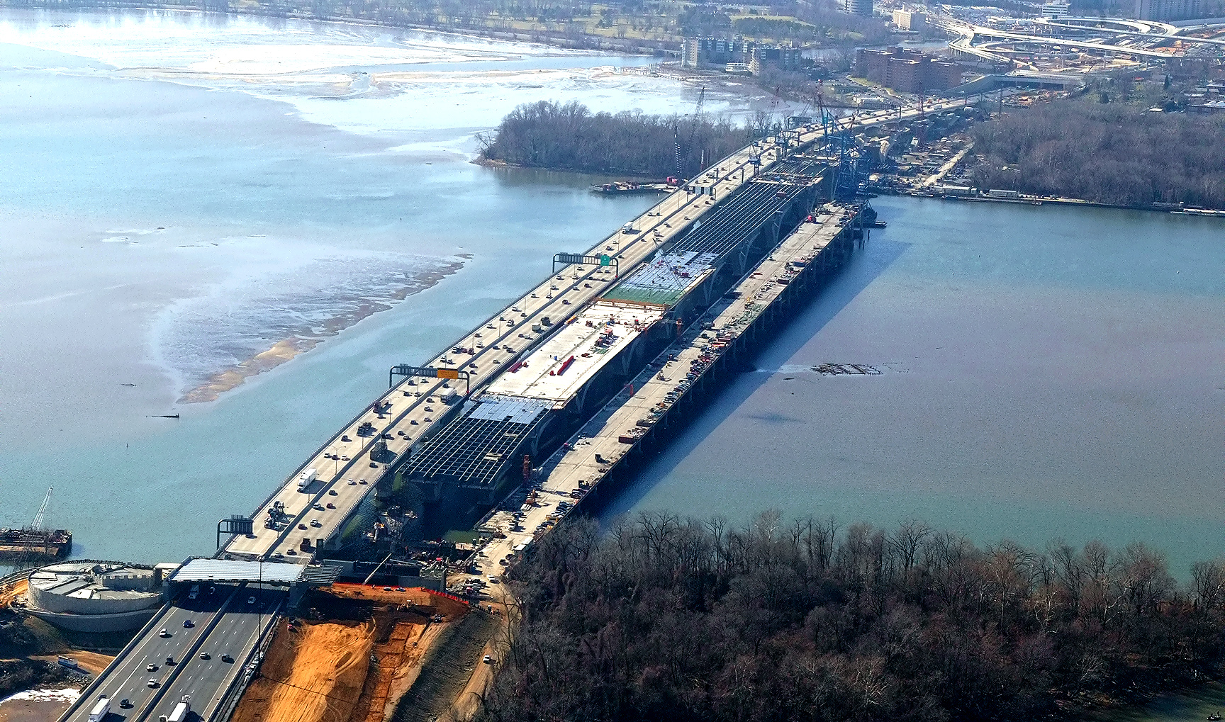
Potomac
River Bridge (Woodrow Wilson Bridge) construction, view of the Bascule Span construction, which is
being built under the Potomac River Bridge Bascule Spans contract.
The 6-lane new bridge for the Outer Loop was opened to traffic in June and
July, 2006, and the second new bridge is under construction. The original
Woodrow Wilson Bridge is behind the bridge under construction. The new
6-lane bridge is on the nearside. The new bascule
span has 70 feet of vertical navigational clearance when the drawspan is closed,
20 feet higher than the original bridge's bascule span which had 50 feet of
vertical navigational clearance when its drawspan was closed. This view is looking north along the Potomac River, with Old Town Alexandria to the left and with downtown Washington, D.C. in the distance. If you look carefully along the left edge of the river, you can see the Washington Monument in the far distance. |
 |
Woodrow Wilson Bridge
construction, looking north, view of the
Potomac River Bridge
Maryland
Approach Spans contract construction, with Maryland in the
background.
The Maryland abutment for the new Potomac River Bridge is visible in the
right of the photo. Interstate 295 Interchange construction, is to the
right. The new 6-lane bridge is on the near side of the construction. A channel was dredged so that construction barges could access the bridge construction site, and the edge of that dredging is visible on the near side of the new bridge as the line where the shallow water (brown tint from the bottom of the river) transitions to deeper water (dark blue water). |
 |
Woodrow Wilson Bridge construction, view of the Maryland Approach Spans construction. Notice the Beltway traffic on the near-side new bridge. The dredging transition line is visible in the bottom of the photo. |
 |
Woodrow Wilson Bridge construction, looking west. Virginia and Old Town Alexandria is on the opposite side of the Potomac River, and Maryland is on the near side of the river. |
 |
Woodrow Wilson Bridge construction, looking west. Virginia and Old Town Alexandria is on the opposite side of the Potomac River, and Maryland is on the near side of the river. |
 |
This is
a zoom-in excerpt
(size 514 kilobytes)
from the previous photo. Larger image (size 1,101 kilobytes) LARGE PHOTO |
 |
Woodrow Wilson Bridge construction, looking west toward Virginia. A channel was dredged so that construction barges could access the bridge construction site, and the edge of that dredging is visible just left of the new bridge as the line where the shallow water (brown tint from the bottom of the river) transitions to deeper water (dark blue water). This photo shows the Potomac River at low tide, and it clearly shows how shallow that this section of the river is in the middle part of the river, where the river bottom ground is almost above water at low tide; and the dark blue water along the Virginia shoreline shows the naturally deep water where the shipping channel is located. |
 |
This is
a zoom-in excerpt (size 520 kilobytes) from the previous photo. Larger image (size 911 kilobytes) LARGE PHOTO These "LARGE PHOTOS" show the U.S. Route 1 Interchange construction in Virginia, in the distance. |
 |
Interstate 295 Interchange and Woodrow Wilson Bridge construction, looking west, with the old closed WWB to the right, the new 6-lane WWB to the left, and the under construction second new 6-lane WWB in the center. |
 |
This is
a zoom-in excerpt (size 574 kilobytes) from the previous photo. Larger image (size 1,431 kilobytes) LARGE PHOTO |
 |
Interstate 295 Interchange and Woodrow Wilson Bridge construction, looking west, with the old closed WWB to the right, the new 6-lane WWB to the left, and the under construction second new 6-lane WWB in the center. |
 |
This is
a zoom-in excerpt (size 810 kilobytes) from the previous photo. Larger image (size 1,260 kilobytes) LARGE PHOTO |
 |
Woodrow Wilson Bridge construction, looking south, view of the Bascule Span construction, which is being built under the Potomac River Bridge Bascule Spans contract. The new 6-lane WWB is behind the bridge under construction. The old bridge's Maryland approach is visible to the left, and its bascule span and Virginia approach spans have been demolished and removed. |
 |
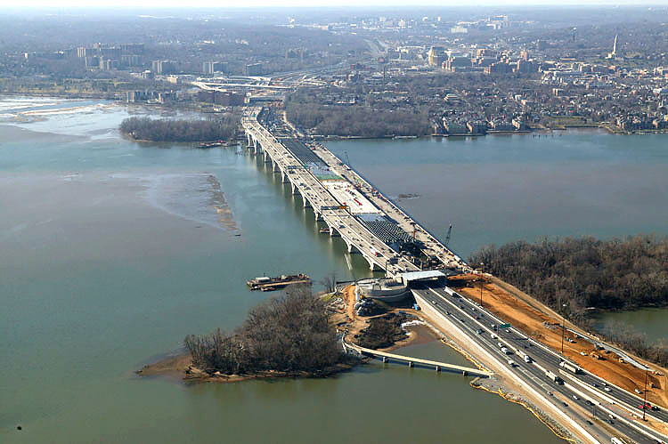
Construction in the center of the photo is the Potomac River Bridge
Virginia Approach Spans contract. The first new 6-lane bridge is
open, and the second new bridge is under construction on the near side,
notice the V-piers under construction on the Virginia overland approach. Jones Point is visible in the upper center of the photo. The Potomac River heads to the south in the distance. |
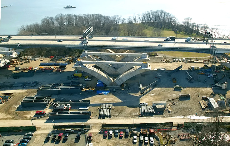 |
Virginia Approach Spans construction underway for the new 6-lane Inner Loop bridge. Jones Point is visible in the upper center of the photo. The Potomac River heads to the south in the distance. |
Lead article - Woodrow Wilson Bridge Project Photos
This article was released on March 4, 2007, with the first 15 photos, numbered 01 thru 15. The last 13 photos, numbered 14 thru 28, were added on March 31, 2007. Large and very large zoom-in excerpt photos were added on April 11, 2007, for photos 22, 23, 24, and 25, and these photos are marked "LARGE PHOTO" in large bold letters next to the photo.
Copyright © 2007 by Scott Kozel. All rights reserved. Reproduction, reuse, or distribution without permission is prohibited.
By Scott M. Kozel, Capital Beltway dot com, Roads to the Future
(Created 3-4-2007, updated 4-11-2007)