
Capital Beltway dot com
| Woodrow Wilson Bridge Project Photos - November 2007 |
The following 85 photos show various aerial views of the I-95/I-495 Woodrow Wilson Bridge (WWB) Project construction, including the new Potomac River Bridge construction, the Virginia VA-241 Telegraph Road Interchange construction, Virginia U.S. Route 1 Interchange construction, the Washington Street Urban Deck construction, and the Maryland Interstate 295 Interchange construction.
These photos were taken on November 20, 2007 by the Virginia Department of Transportation, and are posted here with their permission. Roads to the Future utilized PhotoDeluxe Business Edition to sharpen and brighten and to align all of the photos. Click on the photo to get a large version of the photo. In later versions of Netscape and Internet Explorer, you probably will need to use Full Screen mode (the F11 key can be utilized to swap back and forth between Full Screen and Regular) to see the full size of the large photo without browser-induced image shrinkage. The large photos have sizes ranging from 143 to 394 kilobytes, with most of them being under 285 kilobytes. The photos marked "LARGE PHOTO" are much larger, with a very detailed zoom-in of the previous photo, and they have the file size listed next to the photo. With a broadband or network Internet connection each photo will download within seconds, but with a dial-up Internet connection it will be somewhat slower.
 |
Looking eastward along the Beltway, from above the US-1 interchange construction in Virginia; and visible in the distance are the Woodrow Wilson Bridge, Potomac River and Maryland. The original WWB which is being demolished is to the left and the new 6-lane WWB is to the right, and the under construction (nearing completion) second new 6-lane WWB is in the middle. In the middle part of the photo, the Washington Street Urban Deck over the Beltway has been completed. The Hunting Towers Apartments are to the center right. |
 |
This is
a zoom-in excerpt
(size 549 kilobytes)
from the previous photo. Notice to the left of the new WWB, the last remaining
portions of the original WWB, the pier caps of the Maryland approach of the
bridge are visible at the waterline. Soon those last remaining vestiges of
the original WWB will disappear into history.
The I-295 Interchange construction in Maryland,
is visible in the distance. LARGE PHOTO |
 |
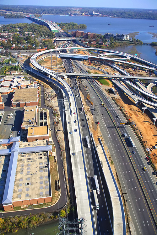
Looking eastward along the Beltway from Virginia, and visible in the distance are the Woodrow Wilson Bridge, Potomac River and Maryland. In the lower left part of the photo, the Washington Street Urban Deck over the Beltway has been completed, and the US-1 interchange construction is visible. The Hunting Towers Apartments are in the middle part of the photo. The I-295 Interchange construction in Maryland, is visible in the distance. |
 |
This
is a large version (size 1,932 kilobytes) of the previous photo. LARGE PHOTO |
 |
Looking eastward along the Beltway, from above the US-1 interchange in Virginia; and visible are the Woodrow Wilson Bridge, Potomac River and Maryland. The remaining vestiges of the original WWB which is being demolished is to the left, and the new 6-lane WWB is to the right, and the under construction (nearing completion) second new 6-lane WWB is in the middle. The recently-opened (in June and July of 2006) new 6-lane Outer Loop Potomac River Bridge, is currently configured to carry 3 Beltway Outer Loop lanes and 3 Beltway Inner Loop lanes. The new 6-lane Inner Loop Potomac River Bridge, to the left of the Outer Loop bridge, is nearing completion, with all foundations built, all superstructure beams placed, and all of the roadway deck has been constructed except for on several spans at the Virginia end of the bridge. The green-colored section, has a grid of green-painted steel re-bars that have been placed on top of forms, awaiting the concrete deck pouring operations; and that is the last remaining section of roadway deck to complete. |
 |
This
is a large version (size 1,475 kilobytes) of the previous photo. LARGE PHOTO |
 |
Interstate 295 Interchange and Woodrow Wilson Bridge construction, looking west. Virginia and Old Town Alexandria is on the opposite side of the Potomac River, and Maryland is on the near side of the river. |
 |
This is a zoom-in excerpt (size 304 kilobytes) from the previous photo.
The U.S. Route 1 Interchange construction in Virginia, is visible in
the distance. Virginia and Old Town Alexandria is on the opposite side
of the Potomac River, and Maryland is on the near side of the river.
Notice to the right of the new WWB, the
last remaining portions of the original WWB, the pier caps of the Maryland
approach of the bridge are visible at the waterline. Soon those last
remaining vestiges of the original WWB will disappear into history.
The small bridge to the left, and the overpass near the end of the WWB,
is part of the pedestrian/bicycle path that will connect the two states
via a separated path along the right edge of the under-construction
Inner Loop WWB. LARGE PHOTO |
 |
Interstate 295 Interchange and Woodrow Wilson Bridge construction, looking west. Virginia and Old Town Alexandria is on the opposite side of the Potomac River, and Maryland is on the near side of the river. |
 |
This is a zoom-in excerpt (size 1,337
kilobytes) from the previous photo. The U.S. Route 1 Interchange construction
in Virginia, is visible in the distance. Virginia and Old Town Alexandria
is on the opposite side of the Potomac River, and Maryland is on the
near side of the river. Notice to the right of the new WWB, the last
remaining portions of the original WWB, the pier caps of the Maryland
approach of the bridge are visible at the waterline. Soon those last
remaining vestiges of the original WWB will disappear into history. LARGE PHOTO |
This article was released on December 15, 2007, with the first 10 photos above. The following 75 photos were added on April 26, 2008.
 |
The I-95/I-495 Capital Beltway and VA-241
Telegraph Road Interchange
(Virginia Exit 176), looking northeast.
This segment of the Beltway will be reconstructed in the Telegraph Road segment of the Woodrow Wilson Bridge Project, a $236 million contract which just began construction, and this contract includes raising the Beltway roadways to provide 5 feet more elevation over Cameron Run to provide a higher resistance to flooding in heavy rainstorm conditions. Per the VDOT Dashboard entry for the project on March 16, 2008, the Contract Award was $236,393,188, the Contract Execution Date was February 12, 2008, and the Original Specified Completion Date is June 30, 2013. The Contract Execution Date includes the Notice to Proceed for the contractor. The construction contractor is CK Constructors, a joint venture of Corman Construction, Inc., and Kiewit Corporation. The contract to rebuild the I-95/I-495 interchange at Telegraph Road, and the remainder of the Beltway between the US-1 Interchange project segment and the Eisenhower Avenue Connector interchange (Virginia Exit 174), will take 5 years to complete. The contract includes 11 ramps and bridges, 5 box culvert extensions, drainage improvements, retaining walls, overhead signs, noise walls, pedestrian paths, landscaping, and environmental mitigation. |
 |
The I-95/I-495 Capital Beltway and Telegraph
Road Interchange, looking north along Telegraph Road. Telegraph Road
is a 4- to 6-lane arterial, and the Beltway interchange is in the
center of the photo. The 8-lane I-95/I-495 Capital Beltway runs left to right, Hunting Creek (also known as Cameron Run) is just below the Beltway. The VA-241 Telegraph Road Interchange of the Beltway was originally built in 1961 as a modified cloverleaf interchange with one semi-directional ramp. The road paralleling just above the Beltway is the 4-lane Eisenhower Avenue, and it has a long bridge over Telegraph Road. Telegraph Road runs bottom to top, and its junctions from bottom to top in order are, North Kings Highway, Huntington Avenue and the first offramp from the Beltway Outer Loop (towards Wilson Bridge) to Telegraph Road, the interchange with the Beltway, an interchange with local roads in the Eisenhower Valley, and the northern terminus of Telegraph Road which has a trumpet interchange with VA-236 Duke Street in Alexandria. The mainline of the CSXT Railroad and the Norfolk Southern Railroad parallels between Eisenhower Avenue and VA-236 Duke Street. Telegraph Road mainline bridges in this photo are, over Hunting Creek, over the mainline railroads, and over Duke Street. |
 |
The I-95/I-495 Capital Beltway and VA-241 Telegraph Road Interchange, looking northwest. |
 |
The I-95/I-495 Capital Beltway and VA-241 Telegraph Road Interchange, looking northwest. |
 |
The 8-lane I-95/I-495 Capital Beltway runs bottom to top, and Hunting Creek (also known as Cameron Run) is just to the left of the Beltway. The VA-241 Telegraph Road Interchange of the Beltway is in the center of the photo, and it was originally built in 1961 as a modified cloverleaf interchange with one semi-directional ramp. The road paralleling to the right of the Beltway is the 4-lane Eisenhower Avenue, and it has a long bridge over Telegraph Road. Telegraph Road runs left to right. |
 |
The 8-lane I-95/I-495 Capital Beltway runs bottom to top, and Hunting Creek is just to the left of the Beltway. Looking west. The VA-241 Telegraph Road Interchange of the Beltway is in the center of the photo. The road paralleling to the right of the Beltway is the 4-lane Eisenhower Avenue, and it has a long bridge over Telegraph Road. Telegraph Road runs left to right. |
 |
The I-95/I-495 Capital Beltway and Telegraph Road Interchange, looking south along Telegraph Road. Telegraph Road is a 4- to 6-lane arterial, and the Beltway interchange is in the center of the photo. The Beltway runs left to right, Hunting Creek is just above the Beltway. The road paralleling just below the Beltway is the 4-lane Eisenhower Avenue, and it has a long bridge over Telegraph Road. Telegraph Road runs lower right to upper left, and its junctions from top to bottom in order are, North Kings Highway, Huntington Avenue and the first offramp from the Beltway Outer Loop (towards Wilson Bridge) to Telegraph Road, the interchange with the Beltway, an interchange with local roads in the Eisenhower Valley, and off the lower edge of the photo is the northern terminus of Telegraph Road which has a trumpet interchange with VA-236 Duke Street in Alexandria. The mainline of the CSXT Railroad and the Norfolk Southern Railroad parallels between Eisenhower Avenue and VA-236 Duke Street. Telegraph Road mainline bridges in this photo are, over Hunting Creek. |
 |
The 8-lane I-95/I-495 Capital Beltway
runs bottom to top, Hunting Creek is just to the right of the Beltway,
the Potomac River is in the upper part of the photo, the U.S. Route
1 Interchange construction is in the upper part of the photo, and
the Woodrow Wilson Bridge is in the upper center of the photo. The
VA-241 Telegraph Road Interchange of the Beltway is in the lower part
of the photo. The WMATA Metro rapid rail transit line Huntington Route (Yellow Line trains) runs on aerial structure left to right across the middle of the photo, and its Eisenhower Avenue Station is visible to the left of the Beltway. |
 |
The 8-lane I-95/I-495 Capital Beltway
runs bottom to top, Hunting Creek is just to the right of the Beltway,
the Potomac River is in the upper part of the photo, the U.S. Route
1 Interchange construction is in the upper part of the photo, and
the Woodrow Wilson Bridge is in the upper center of the photo. The
VA-241 Telegraph Road Interchange of the Beltway is in the lower part
of the photo. The WMATA Metro rapid rail transit line Huntington Route (Yellow Line trains) runs on aerial structure left to right across the lower part of the photo, and its Eisenhower Avenue Station is visible to the left of the Beltway. |
 |
The WMATA Metro rapid rail transit line Huntington Route (Yellow Line trains) runs on aerial structure bottom to top across the middle of the photo, and its Eisenhower Avenue Station is visible in the lower part of the photo. The I-95/I-495 Capital Beltway runs across the bottom of the photo, and the Metro line passes over the Beltway. |
 |
The I-95/I-495 Capital Beltway runs lower left to upper right, Hunting Creek is just to the right of the Beltway, the Potomac River is in the upper part of the photo, the U.S. Route 1 Interchange construction is in the upper right part of the photo, and the Woodrow Wilson Bridge is in the upper right of the photo. Alexandria, Virginia is on the north side of (above) the Beltway. Virginia is on this side of the Potomac River, and Maryland and Washington, D.C. is on the opposite side of the river. |
 |
The I-95/I-495 Capital Beltway runs lower left to upper right, Hunting Creek is just to the right of the Beltway, the Potomac River is in the upper part of the photo, the U.S. Route 1 Interchange (Virginia Exit 177) construction is in the center of the photo, and the Woodrow Wilson Bridge is in the center of the photo. Alexandria, Virginia is on the north side of (above) the Beltway. Virginia is on this side of the Potomac River, and Maryland and Washington, D.C. is on the opposite side of the river. |
 |
The I-95/I-495 Capital Beltway runs lower left to upper right, Hunting Creek is just to the right of the Beltway, the Potomac River is in the upper part of the photo, the U.S. Route 1 Interchange construction is in the upper right part of the photo, and the Woodrow Wilson Bridge is in the upper right of the photo. |
 |
The I-95/I-495 Capital Beltway runs left to right, this is part of the U.S. Route 1 Interchange construction in Virginia. Notice the elevated ramps under construction in the center of the photo, they are part of the local ramps that will connect the Eisenhower Valley in Alexandria, Virginia, to the Beltway's traffic to and from Maryland. The long new bridge on the near side of the Beltway, is part of the completed US Route 1 Interchange Advanced Bridge contract, and the bridge will carry the Beltway Outer Loop local roadway; currently it is carrying local traffic exiting the Beltway to US-1. |
 |
The I-95/I-495 Capital Beltway runs lower
left to upper right, Hunting Creek is just to the right of the Beltway,
the Potomac River is in the upper part of the photo, the U.S. Route
1 Interchange construction is in the center of the photo, and the
Woodrow Wilson Bridge is in the upper right of the photo. Virginia
is on this side of the Potomac River, and Maryland is on the opposite
side. The downward curving elevated ramp at the middle of the photo is the newly opened flyover ramp from northbound US-1 to the Beltway Inner Loop (toward Springfield), and this ramp opened to traffic on May 6, 2007. |
 |
The I-95/I-495 Capital Beltway runs lower left to upper right, Hunting Creek is just to the right of the Beltway, the Potomac River is in the upper part of the photo, the U.S. Route 1 Interchange construction is in the center of the photo, and the Woodrow Wilson Bridge is in the upper right of the photo. Virginia is on this side of the Potomac River, and Maryland is on the opposite side. |
 |
Looking west along the I-95/I-495 Capital
Beltway, showing construction of the U.S. Route 1 Interchange. Notice the new 3-lane southbound US-1 bridge under construction, which passes over Hunting Creek, low-lying land, and the Beltway. The new 3-lane northbound US-1 bridge is temporarily carrying 2 lanes each way. |
 |
Looking west along the I-95/I-495 Capital
Beltway, showing construction of the U.S. Route 1 Interchange. Notice the new 3-lane southbound US-1 bridge under construction, which passes over Hunting Creek, low-lying land, and the Beltway. The new 3-lane northbound US-1 bridge is temporarily carrying 2 lanes each way. A segment of the Beltway Inner Loop local roadway was recently completed, and Inner Loop traffic was shifted to it a few weeks previously, and that is visible just beyond the US-1 bridges. Notice the abandoned former segment of Inner Loop roadway. |
 |
Looking southwest along the I-95/I-495 Capital Beltway, showing construction of the U.S. Route 1 Interchange. The upward curving elevated ramp at the bottom of the photo is the newly opened flyover ramp from northbound US-1 to the Beltway Inner Loop (toward Springfield), and this ramp opened to traffic on May 6, 2007. |
 |
Looking south along US-1, showing construction
of the U.S. Route 1 Interchange. Notice the new 3-lane southbound US-1 bridge under construction, which passes over Hunting Creek, low-lying land, and the Beltway. The new 3-lane northbound US-1 bridge is temporarily carrying 2 lanes each way. |
 |
U.S. Route 1 Interchange construction, looking south across the Beltway and Hunting Creek, with the Beltway running left to right. The Potomac River is visible in the upper left of the photo. |
 |
U.S. Route 1 Interchange construction, looking south across the Beltway and Hunting Creek, with the Beltway running left to right. The Potomac River is visible in the upper left of the photo. |
 |
U.S. Route 1 Interchange construction, looking south across the Beltway and Hunting Creek, with the Beltway running left to right. The Potomac River is visible in the upper left of the photo. |
 |
The I-95/I-495 Capital Beltway runs bottom to top, Hunting Creek (also known as Cameron Run) is just to the right of the Beltway, the Potomac River is in the upper part of the photo, the U.S. Route 1 Interchange construction is in the upper part of the photo, and the Woodrow Wilson Bridge, and Maryland, is in the upper part of the photo. |
 |
The I-95/I-495 Capital Beltway runs bottom to top, Hunting Creek is just to the right of the Beltway, the Potomac River is in the upper part of the photo, the U.S. Route 1 Interchange construction is in the upper part of the photo, and the Woodrow Wilson Bridge, and Maryland, is in the upper part of the photo. |
 |
The I-95/I-495 Capital Beltway runs bottom to top, Hunting Creek is just to the right of the Beltway, the Potomac River is in the upper part of the photo, the U.S. Route 1 Interchange construction is in the upper part of the photo, and the Woodrow Wilson Bridge is in the upper part of the photo. Notice the elevated ramps under construction in the lower left of the photo, they are part of the local ramps that will connect the Eisenhower Valley in Alexandria, Virginia, to the Beltway's traffic to and from Maryland. The long new bridge on the right side of the Beltway, is part of the completed US Route 1 Interchange Advanced Bridge contract, and the bridge will carry the Beltway Outer Loop local roadway; currently it is carrying local traffic exiting the Beltway to US-1. |
 |
The I-95/I-495 Capital Beltway runs bottom to top, Hunting Creek is just to the right of the Beltway, the Potomac River is in the upper part of the photo, the U.S. Route 1 Interchange construction is in the upper part of the photo, and the Woodrow Wilson Bridge is in the upper part of the photo. |
 |
U.S. Route 1 Interchange construction, looking north across Hunting Creek and the I-95/I-495 Capital Beltway, with Alexandria on the north side of the Beltway. |
 |
Mount Vernon Memorial Highway runs from the bottom of the photo, upward past the apartment complex where the Mount Vernon Memorial Highway becomes Washington Street, and Washington Street crosses the Beltway and goes into Old Town Alexandria. The Beltway runs left-right across the center of the photo. The Washington Street Urban Deck is under construction in the center of the photo. Old Town Alexandria is in the upper part of the photo, and National Airport, downtown Washington, D.C., and the Washington Monument is in the far distance. The Virginia approach of the Woodrow Wilson Bridge, begins in the right of the photo. |
 |
Mount Vernon Memorial Highway runs from the bottom of the photo, upward past the apartment complex where the Mount Vernon Memorial Highway becomes Washington Street, and Washington Street crosses the Beltway and goes into Old Town Alexandria. The Beltway runs left-right across the center of the photo. The Washington Street Urban Deck is under construction in the center of the photo. Old Town Alexandria is in the upper part of the photo, and National Airport, and downtown Washington, D.C., is in the far distance. |
 |
Virginia approaches construction to the Potomac River Bridge, looking north. Construction in the foreground is the Potomac River Bridge Virginia Approach Spans contract, and the new 6-lane Outer Loop WWB is visible, and it is carrying 3 lanes each way until the second new 6-lane Inner Loop WWB, which is under construction above the new bridge, opens to traffic in mid-2008. The new Virginia abutment for the Potomac River Bridge is visible in the left of the photo. |
 |
Virginia approaches construction to the Potomac River Bridge, looking west. Construction in the foreground is the Virginia Approach Spans contract, and the new 6-lane Outer Loop WWB is visible to the left, and it is carrying 3 lanes each way until the second new 6-lane Inner Loop WWB, which is under construction to the right, opens to traffic in mid-2008. The new Virginia abutment for the Potomac River Bridge is visible in the center of the photo, and the land approach construction is visible above that, and the Washington Street Deck construction is visible, with the U.S. Route 1 Interchange construction visible in the distance. |
 |
Virginia approaches construction to the Potomac River Bridge, looking west. Construction in the foreground is the Virginia Approach Spans contract, and the new 6-lane Outer Loop WWB is visible to the left, and it is carrying 3 lanes each way until the second new 6-lane Inner Loop WWB, which is under construction to the right, opens to traffic in mid-2008. |
 |
Virginia approaches construction to the Potomac River Bridge, looking west. |
 |
Virginia approaches construction to the Potomac River Bridge, looking west. |
 |
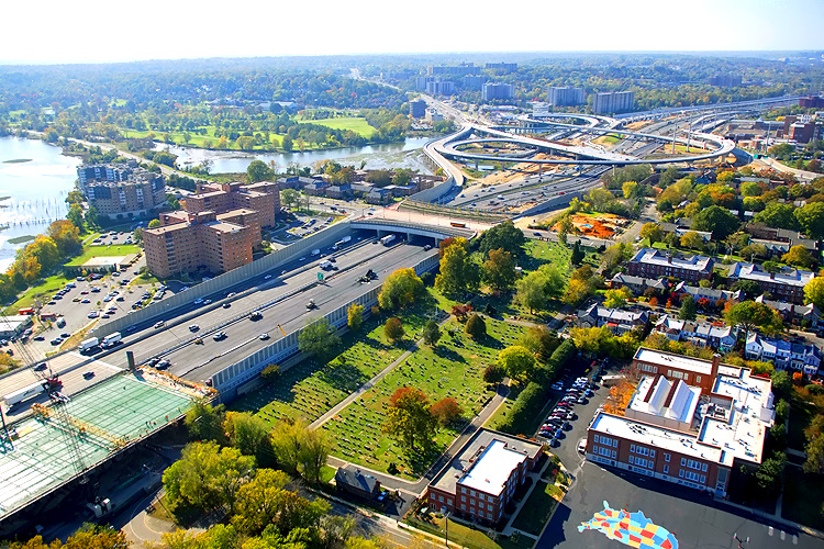
Looking southwest along the Beltway, showing
construction of the Washington Street Urban Deck in Alexandria VA,
and the U.S. Route 1 Interchange in the distance. The Washington Street
Urban Deck has been completed over the future local and express Beltway
Outer Loop roadways, and over the future local and express Beltway
Inner Loop roadways. The Washington Street Urban Deck is over 200
feet wide, will be landscaped, and will remove the 'barrier effect'
to pedestrians that would exist with a simple replacement of the 4-lane
Washington Street overpass over the 12-lane Beltway. The Virginia end of the WWB is visible in the lower left corner of the photo, and the Hunting Towers apartment building are in the upper left of the photo. In the foreground is St. Mary’s Cemetery, which was established in the late 1700’s. |
 |
Looking southwest along the Beltway, showing
construction of the Washington Street Urban Deck in Alexandria VA,
and the U.S. Route 1 Interchange in the distance. The Washington Street
Urban Deck has been completed over the future local and express Beltway
Outer Loop roadways, and over the future local and express Beltway
Inner Loop roadways. The Virginia end of the WWB is visible in the lower left corner of the photo, and the Hunting Towers apartment building are in the left of the photo. |
 |
Virginia approaches construction to the Potomac River Bridge, looking south. |
 |
Looking eastward along the Beltway, from above the Old Town Alexandria in Virginia; and visible are the Woodrow Wilson Bridge, Potomac River and Maryland. |
 |
Looking eastward along the Beltway, from above the US-1 interchange in Virginia; and visible are the Woodrow Wilson Bridge, Potomac River and Maryland. The remaining vestiges of the original WWB which is being demolished is to the left, and the new 6-lane WWB is to the right, and the under construction (nearing completion) second new 6-lane WWB is in the middle. The recently-opened (in June and July of 2006) new 6-lane Outer Loop Potomac River Bridge, is currently configured to carry 3 Beltway Outer Loop lanes and 3 Beltway Inner Loop lanes. The new 6-lane Inner Loop Potomac River Bridge, to the left of the Outer Loop bridge, is nearing completion, with all foundations built, all superstructure beams placed, and all of the roadway deck has been constructed except for on several spans at the Virginia end of the bridge. The green-colored section, has a grid of green-painted steel re-bars that have been placed on top of forms, awaiting the concrete deck pouring operations; and that is the last remaining section of roadway deck to complete. |
 |
Looking eastward along the Beltway, from above the US-1 interchange in Virginia; and visible are the Woodrow Wilson Bridge, Potomac River and Maryland. |
 |
Looking north along US-1, showing construction
of the U.S. Route 1 Interchange. Notice the new 3-lane southbound US-1 bridge under construction, which passes over Hunting Creek, low-lying land, and the Beltway. The new 3-lane northbound US-1 bridge is temporarily carrying 2 lanes each way. |
 |
Looking northeastward along the Beltway, from just south of the US-1 interchange in Virginia; and visible in the distance are the Woodrow Wilson Bridge, Potomac River and Washington. The Hunting Towers Apartments are to the right. The Washington Street Urban Deck has been completed over the future local and express Beltway Outer Loop roadways, with Beltway traffic operating there; and it is completed over the future local and express Beltway Inner Loop roadways. |
 |
Looking eastward along the Beltway from Virginia, and visible in the distance are the Woodrow Wilson Bridge, Potomac River and Washington. The Hunting Towers Apartments are in the lower part of the photo. |
 |
Virginia approaches construction to the Potomac River Bridge, looking east toward Maryland. Construction is the Potomac River Bridge Virginia Approach Spans contract. The end of the WWB is visible in the left of the photo. |
 |
Virginia approaches construction to the Potomac River Bridge, looking east toward Maryland and Washington. |
 |
Potomac River Bridge construction, looking east toward Washington and Maryland. Jones Point is visible in the right of the photo. |
 |
Virginia approaches construction to the Potomac River Bridge, looking east toward Washington and Maryland. |
 |
Potomac River Bridge construction, view of the Bascule Span construction, which is being built under the Potomac River Bridge Bascule Spans contract. The new bascule span has 70 feet of vertical navigational clearance when the drawspan is closed, 20 feet higher than the original bridge's bascule span which had 50 feet of vertical navigational clearance when its drawspan was closed. |
 |
Potomac River Bridge construction. |
 |
Potomac River Bridge construction, view of part of the bascule span, notice the fender ring under construction around the waterline of the pier. The fender is to prevent barges and ships from being able to collide with the pier. |
 |
Potomac River Bridge construction, view of part of the bascule span, notice the fender ring under construction around the waterline of the pier. The fender is to prevent barges and ships from being able to collide with the pier. |
 |
Potomac River Bridge (Woodrow Wilson Bridge)
construction, view of the Bascule Span construction, which is being
built under the Potomac River Bridge Bascule Spans contract.
The 6-lane new bridge for the Outer Loop was opened to traffic in
June and July, 2006, and the second new bridge is under construction.
The original Woodrow Wilson Bridge was behind the bridge under construction.
The new 6-lane bridge is on the nearside. The new bascule span has
70 feet of vertical navigational clearance when the drawspan is closed,
20 feet higher than the original bridge's bascule span which had 50
feet of vertical navigational clearance when its drawspan was closed. This view is looking north along the Potomac River, with Old Town Alexandria to the left and with downtown Washington, D.C. in the distance. If you look carefully along the left edge of the river, you can see the Washington Monument in the far distance. |
 |
Woodrow Wilson Bridge construction, looking northeast, view of the Maryland Approach Spans contract construction, which is being built under the Potomac River Bridge Maryland Approach Spans contract, with Maryland in the background. The Maryland abutment for the new Potomac River Bridge is visible in the right of the photo. Interstate 295 Interchange construction, is to the right. The new 6-lane bridge is on the near side of the construction. |
 |
Woodrow Wilson Bridge construction, looking northeast, view of the Maryland Approach Spans contract construction, with Maryland in the background. The Maryland abutment for the new Potomac River Bridge is visible in the right of the photo. Interstate 295 Interchange construction, is to the right. The new 6-lane bridge is on the near side of the construction. |
 |
Woodrow Wilson Bridge construction, looking north, view of the Maryland Approach Spans contract construction. The new 6-lane bridge is on the near side of the construction. |
 |
Woodrow Wilson Bridge construction, looking north, view of the Maryland Approach Spans contract construction. The new 6-lane bridge is on the near side of the construction. |
 |
Potomac River Bridge (Woodrow Wilson Bridge) construction, view of the Maryland Approach Spans construction. The Maryland abutment (terminal structure) of the new Potomac River Bridge is visible in the left of the photo, on Rosalie Island. Land Beltway roadway construction, between Rosalie Island and the Maryland mainland, is to the right. The overpass near the end of the WWB, is part of the pedestrian/bicycle path that will connect the two states via a separated path along the right edge of the under-construction Inner Loop WWB. Notice the pedestrian path under construction between Rosalie Island and the Maryland mainland. There will be a separate pedestrian/bicycle trail on the north side of the second new Woodrow Wilson Bridge, and the trail will carry pedestrian/bicycle traffic between US-1 south of Alexandria and pedestrian/bicycle trails in Maryland. |
 |
Interstate 295 Interchange construction, looking east, the Potomac River Bridge is just off of the left edge of the photo, and the I-95/I-495 Beltway sweeps into the distance, with I-295 curving left to right as it extends to MD-210 Indian Head Highway in the distance. |
 |
Interstate 295 Interchange construction,
looking east. High capacity roadways and ramps are being constructed
to make this a 4-way interchange, with the southerly extension heading
into the National Harbor development to the right which began construction
in 2004. Website for National Harbor |
 |
Interstate 295 Interchange construction, looking east along the I-95/I-495 Capital Beltway. High capacity roadways and ramps are being constructed to make this a 4-way interchange, with the southerly extension heading into the National Harbor development to the right which began construction in 2004. |
 |
Interstate 295 Interchange construction, looking east along the I-95/I-495 Capital Beltway. Notice the massive parking area under construction to the right, for the National Harbor development. |
 |
Interstate 295 Interchange construction, looking east. Notice the massive parking area under construction in the center, for the National Harbor development. A circular highway is being constructed that will loop all the way around the parking area. |
 |
Interstate 295 Interchange construction, looking west along the I-95/I-495 Beltway. The Woodrow Wilson Bridge across the Potomac River is in the upper center part of the photo. I-295 curves over the Beltway on the two new bridges to the right, and I-295 terminates at MD-210 Indian Head Highway about a mile to the east. The two new bridges to the left are ramps connecting the Beltway Outer Loop to I-295. |
 |
Interstate 295 Interchange construction, looking west along the I-95/I-495 Beltway. The Woodrow Wilson Bridge across the Potomac River is in the upper right part of the photo, and Virginia is on the opposite side of the Potomac River. Inner Loop traffic on the segment between east of MD-210 and west of I-295, was shifted to the newly constructed permanent Inner Loop local roadway, a couple weeks ago. At this section, both the Inner Loop and the Outer Loop roadways are on their respective new local roadway, and in between them the new 3-lane express roadways are under construction. |
 |
Potomac River Bridge construction, looking south, view of the Maryland Approach Spans construction, which is being built under the Potomac River Bridge Maryland Approach Spans contract. The first new 6-lane bridge is open, and the second new 6-lane bridge is under construction on the near side. On the near side of the new WWB, the last remaining portions of the original WWB, the pier caps of the Maryland approach of the bridge, are being demolished at the waterline. |
 |
Potomac River Bridge construction, looking south, view of the Maryland Approach Spans construction. On the near side of the new WWB, the last remaining portions of the original WWB, the pier caps of the Maryland approach of the bridge, are being demolished at the waterline, that is what the barges are being used for. |
 |
Potomac River Bridge construction, view of the Bascule Span construction, which is being built under the Potomac River Bridge Bascule Spans contract. The new drawbridge Operator's Tower is visible in the upper left of the photo. |
 |
Potomac River Bridge construction, view of the Bascule Span construction. Notice the fender ring under construction around the waterline of the pier. The fender is to prevent barges and ships from being able to collide with the pier. The recently-opened (in June and July of 2006) new 6-lane Outer Loop Potomac River Bridge, is currently configured to carry 3 Beltway Outer Loop lanes and 3 Beltway Inner Loop lanes. The new 6-lane Inner Loop Potomac River Bridge, to near side of the Outer Loop bridge, is nearing completion, with all foundations built, all superstructure beams placed, and all of the roadway deck has been constructed except for on several spans at the Virginia end of the bridge. |
 |
Construction in the center of the photo is the Potomac River Bridge Virginia Approach Spans contract. Jones Point is visible in the upper center of the photo. The Potomac River heads to the south in the distance. The first new 6-lane bridge is open, and the second new 6-lane bridge is under construction on the near side. |
 |
Construction in the center of the photo is the Virginia Approach Spans contract. The Potomac River heads to the south in the distance. The first new 6-lane bridge is open, and the second new 6-lane bridge is under construction on the near side, notice the superstructure under construction on the Virginia overland approach. The Virginia abutment (terminal structure) of the new bridge is in the lower right of the photo. |
 |
Construction in the left of the photo is the Virginia Approach Spans contract. The first new 6-lane bridge is open, and the second new 6-lane bridge is under construction on the near side, notice the superstructure under construction on the Virginia overland approach. The Virginia abutment (terminal structure) of the new bridge is in the center of the photo. Closer view of the roadway deck construction on the Inner Loop bridge at the Virginia end of the bridge. The green-colored section, has a grid of green-painted steel re-bars that have been placed on top of forms, awaiting the concrete deck pouring operations; and that is the last remaining section of roadway deck to complete. Land Beltway roadway construction is to the right. In the foreground is St. Mary’s Cemetery, which was established in the late 1700’s. |
Lead article - Woodrow Wilson Bridge Project Photos
This article was released on December 15, 2007, with the first 10 photos, numbered 01 thru 05, with large versions numbered 01x thru 05x. The 75 photos, numbered 06 thru 80, were added in this update.
Copyright © 2007-2008 by Scott Kozel. All rights reserved. Reproduction, reuse, or distribution without permission is prohibited.
By Scott M. Kozel, Capital Beltway dot com, Roads to the Future
(Created 12-15-2007, updated 4-26-2008)